- Bow Valley Insider
- Posts
- Why Jasper Burned So Fast: What the Science Now Says
Why Jasper Burned So Fast: What the Science Now Says
New studies show warning signs that went unnoticed
Bow Valley Insider
October 21, 2025
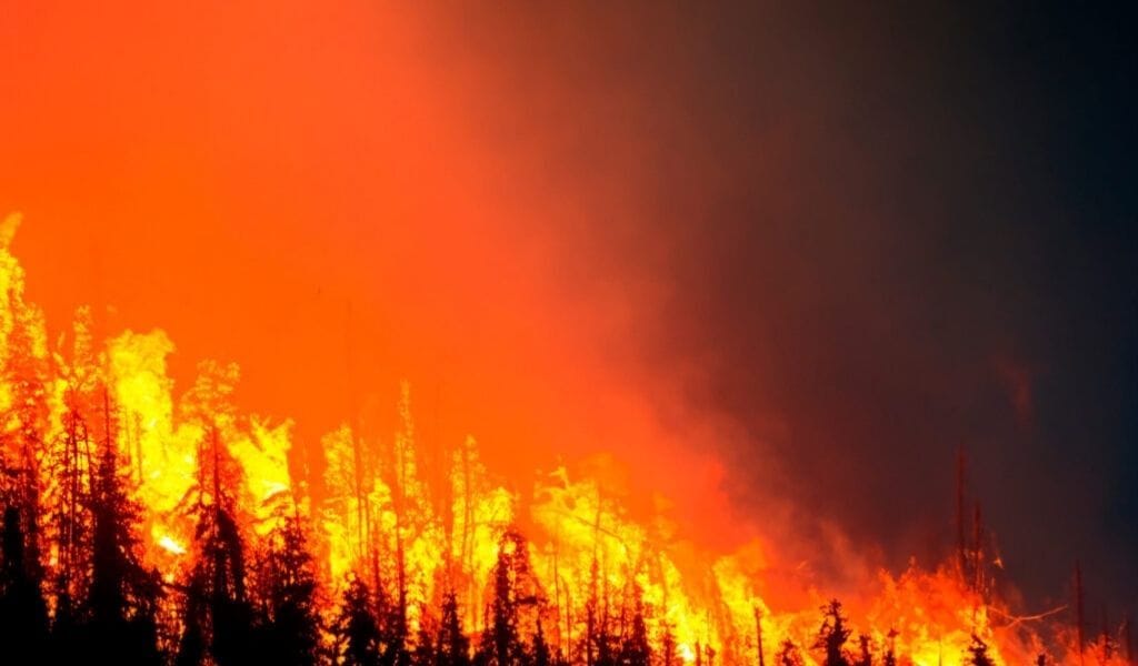
Late in the afternoon of July 24, 2024, the sky above Jasper shifted to an orange haze. Hours later, a blast of heat and embers swept down from the mountainside, igniting neighbourhoods on the town’s edge. By nightfall, 358 structures were gone, marking one of the most destructive wildfires in modern Canadian history.
For months, researchers from Natural Resources Canada (NRCan) and FPInnovations, a Canadian forest research institute that specializes in wildfire and structural impact analysis, combed through the ashes, tree rings, roof tiles, and satellite data to understand a question that haunted both residents and wildfire scientists: how could a fire move so fast?
Their findings, published in October 2025, paint the clearest scientific picture yet of how a perfect storm of drought, forest health decline, wind, and urban design turned a natural event into a catastrophe.
The Fire That Wouldn’t Slow Down
According to NRCan’s Jasper 2024 Wildfire Complex Analysis, the disaster began on the evening of July 22 when three lightning strikes ignited fires 23 kilometers south of the Jasper townsite. Within hours, those small ignitions merged into what scientists called the “South Fire,” feeding on tinder-dry conifer forests in the upper Athabasca valley.
A fourth lightning strike east of town created the “North Fire,” diverting early firefighting resources, but the South Fire became the true threat. Over the next 50 hours, it advanced steadily toward the community. The report notes that “persistent severe to extreme wildfire behaviour made direct suppression efforts impossible,” and that the fire remained active “even when surface winds were light.”
Firefighters could not get in front of it. Instead, they braced for impact.
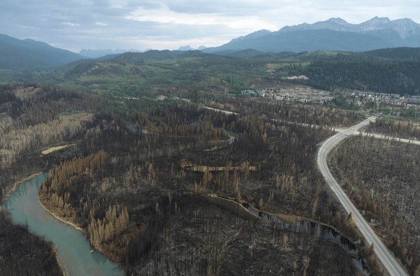
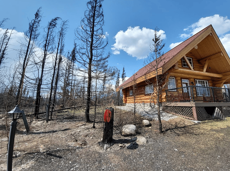
View looking northwest at the post-fire consumption of the wildland fuels leading up to the southwest side of Jasper townsite
The Ingredients of a Perfect Firestorm
The NRCan report identifies eight main factors behind Jasper’s destruction. None were extraordinary on their own. Together, they created a once-in-a-century event.
1. Drought
In the month before the fire, Jasper experienced almost no rain and daily highs in the mid-30s. “Lack of rainfall and a heat wave… significantly reduced fuel moisture, making nearly all surface fuels available for combustion,” the report found. This meant grass, needles, shrubs, and even decayed wood could burn easily, creating continuous pathways for flames to travel.
2. Continuous and beetle-killed fuels
Tree mortality from the mountain pine beetle left behind what researchers described as “a wind-aligned corridor for fire spread.” When the beetles killed trees between 2016 and 2018, the needles dropped to the forest floor, adding a mat of flammable debris, while the dry trunks remained upright like torches.
“These early grey-stage stands, six to eight years post-attack, contained an abundance of dry woody fuel,” the report explained, creating conditions that amplified both fuel consumption and fire intensity.
3. Rapid ignition and acceleration
The fires merged into a single front of more than 3,500 hectares within hours. “High-intensity crown fire behaviour developed within minutes, beyond the capacity of initial attack resources,” the analysis found.
That meant the fire wasn’t just burning along the forest floor but leaping from canopy to canopy, creating walls of flame that made aerial drops and ground suppression largely ineffective.
4. Plume-driven fire behaviour
As flames climbed steep valley slopes, they generated their own weather system. “High fuel consumption, moderate surface winds, and steep slopes promoted towering convection columns with strong updrafts,” NRCan reported. Near the main column, “fire-generated wind speeds… reached up to 200 km/h.”
5. Column collapse and ember transport
This was the turning point. As the convection column over the South Fire rose and then collapsed, it sent a downburst of heat and burning material cascading into Jasper. “The column collapse likely transported embers more than 2 km into receptive fuels in and near the Jasper townsite,” igniting spot fires across roofs and lawns.
In the words of the report: “The first structures ignited shortly thereafter.”
FPInnovations’ companion report, Jasper Community Wildfire Impact Research, corroborates this. “At approximately 17:45 on July 24, there was a change in the wildfires’ column dynamics and it collapsed on the town, bringing a considerable ember shower into and around the southwest end of town.”
What followed was not a forest fire but an urban firestorm.
When the Fire Became Urban
FPInnovations researchers arrived days later to map what was left. They interviewed firefighters, analyzed drone footage, and compared burned and unburned houses block by block. Their findings form a forensic map of vulnerability, showing that the difference between a house that survived and one reduced to a foundation was often measured in meters.
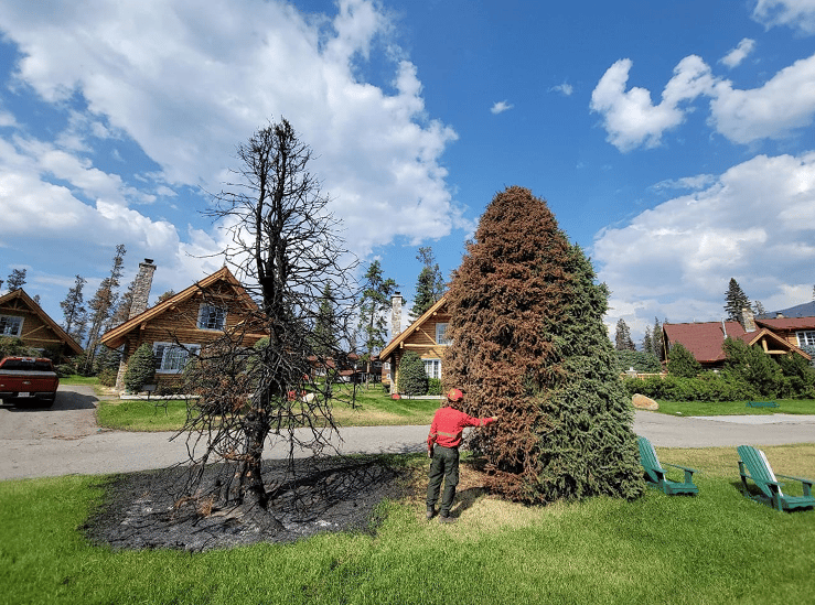
Full consumption of a manicured spruce next to an unburned tree of similar characteristics.
“Wildfire embers ignited many structures directly… and indirectly via flammable items surrounding a structure. Once structures ignited, strong winds drove fire growth through the densely built-up neighbourhoods, with structure-to-structure ignition dominating the spread.”
Roofs and spacing proved decisive.
“Wooden roofing materials and their commonly associated structural characteristics likely increased the risk of ignition,” researchers found. And when spacing between buildings was “less than 5 meters, there was a high likelihood of structure-to-structure ignition.”
Landscaping mattered too.
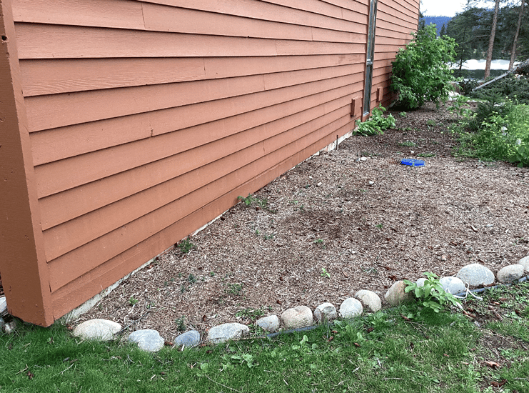
Mulch under combustible siding on the shore of Beauvert Lake
Combustible mulch beds, firewood piles, and wooden decks acted as ignition points. The study concluded that “continuous pathways of wildland fuels up to the structure” were a leading risk factor. Even small gaps could let embers nest under siding or soffits, smoldering unseen until houses caught fire from within.
Why Some Areas Survived
Not every part of Jasper burned. NRCan credited nearly two decades of proactive fuel treatment work around the town. Since 2003, Parks Canada crews had thinned dense stands of conifer trees, removed low branches that can carry flames into the canopy, and cleared dead or beetle-killed timber in the forests surrounding the community. The goal was to break up continuous fuels that allow fires to climb upward and spread uncontrollably.
“Hazard reduction treatments around Jasper, implemented since 2003, moderated fire behaviour in fuel patches surrounding the townsite,” the report said. In treated areas, “crown involvement, fuel consumption, and estimated fire intensity were lower,” which “reduced ember production and limited the exposure of nearby structures to ignition.”
That preparation saved key assets. Two-thirds of the townsite and all critical infrastructure were protected. Still, the fire exposed how extreme events can leapfrog even well-managed buffers.
The Limits of Prediction
The NRCan analysis emphasized how unusual the weather patterns were during the fire. Despite strong winds on nearby ridges, conditions in the valley bottom stayed surprisingly calm, creating a brief lull before the fire surged into town. This combination of light surface winds and powerful rising heat made it almost impossible to predict when the fire would suddenly accelerate.
Scientists noted that fire-driven weather effects, such as strong upward air currents and shifting winds, likely played a major role in speeding up the spread. These effects are difficult to measure or include in forecasting models, which helps explain why the fire’s rapid movement caught even experienced crews off guard.
From Forest Management to Urban Design
Both reports converge on one message: wildfires like Jasper’s cannot be stopped by firefighting alone. “Strengthening resilience requires an integrated approach, including landscape risk assessment and management, increasing fire-resistance in the built environment, and effective pre-response planning,” NRCan concluded.
Close view of the side of the unburned structure showing the direction fire approached from.
FPInnovations’ findings drive that point home. The same structural patterns observed in Jasper mirror those in other recent Canadian fires, including Kelowna’s 2023 Grouse Complex and the Hamlet of Enterprise in the Northwest Territories. Each event reinforces the link between building materials, spacing, and survival.
As project lead Brandon MacKinnon wrote, “Features such as roofing material, spacing between structures, combustible items around the base of the structure, and continuous pathways of wildland fuels up to the structure were identified as potential risk factors associated with structure loss.”
The Bigger Picture
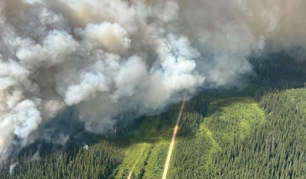
Aerial view of Jasper Wildfire
The 2024 Jasper wildfire was not just a local disaster but a national warning. The analysis ties its intensity to long-term ecological change. “Over a century of fire exclusion in the upper Athabasca valley shifted the landscape from a mix of open and closed forests to a more uniform, fire-prone structure,” NRCan wrote, adding that this increased “the potential for large and uncontrollable fires.”
In other words, the fire that destroyed parts of Jasper was the product of a century of well-intentioned suppression. The lesson is uncomfortable: by preventing smaller burns, we created the conditions for a bigger one.
Looking Ahead
The federal review of the wildfire response is still underway and will continue into 2026. But these two reports already outline a roadmap for Canada’s new fire reality.
Landscape management can reduce fire intensity, but it must be paired with urban resilience, including fire-resistant roofing, wider spacing between buildings, and materials that are less likely to ignite. Parks Canada has indicated that lessons from Jasper will inform new FireSmart standards for national park communities.
As the NRCan scientists concluded, “The Jasper South Fire exemplifies the increasing challenge of managing extreme wildfire events in Canada’s evolving fire landscape.” Their analysis, they wrote, is intended to “refine fire management strategies and enhance resilience to future wildfire threats.”
In Jasper, that work has already begun. For the rest of Canada, the research is a preview of what is coming: fires that behave less like natural disturbances and more like fast-moving urban disasters, testing the limits of science, infrastructure, and our ability to adapt.
Reply