- Bow Valley Insider
- Posts
- Historic Avalanche Cycle Expected in Banff This Week
Historic Avalanche Cycle Expected in Banff This Week
Forecasters warn avalanches could reach valley bottoms as a multi day storm pushes conditions to extreme levels
Bow Valley Insider
March 17, 2026
A powerful storm system moving into the Rockies this week is expected to trigger a widespread and potentially historic avalanche cycle across Banff National Park and surrounding mountain regions, with conditions forecast to worsen through Friday.
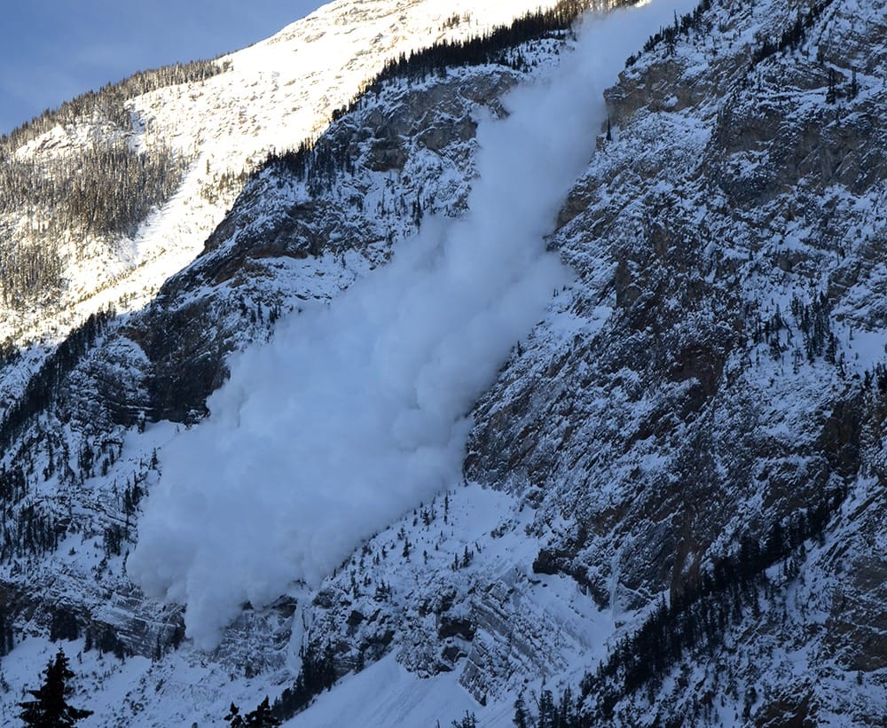
Forecasters warn that very large avalanches could run farther than usual and reach valley bottoms, creating dangerous conditions even in areas that are typically considered lower risk.
Atmospheric River Bringing Heavy Snow and Rain
The region is entering a period of warm, wet weather driven by a series of atmospheric rivers. These long plumes of tropical moisture are known for delivering intense precipitation and rising freezing levels.
In this case, freezing levels are expected to climb to between 1,900 and 2,300 metres, meaning rain could fall at lower elevations while heavy snow accumulates higher up. Total precipitation could reach 40 to 80 centimetres or more by the end of the week.
At the same time, strong to extreme south and southwest winds are redistributing snow and adding additional stress to the snowpack.
Avalanche danger rising to extreme
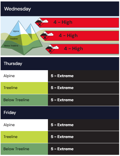
Avalanche danger is already rated high across all elevations on Wednesday and is expected to increase to extreme on Thursday and Friday.
At the extreme level, natural and human triggered avalanches are considered certain, with very large avalanches expected in many areas.
Why conditions are so dangerous
Recent snow and rain have added a lot of weight to an already fragile snowpack.
“We expect large avalanches to run to historic runouts over the next several days,” the avalanche bulletin from Avalanche Canada states.
Forecasters say there are weak layers buried beneath the surface that can easily collapse under pressure. When that happens, it can trigger avalanches that break wide across the slope.
With more snow, rain, and strong winds expected, that pressure will continue to build. That means avalanches could become larger, more powerful, and travel farther than usual.
Travel advice
Officials are clear that this is not a time to be in avalanche terrain.
Travel in avalanche terrain is not recommended under high danger and should be completely avoided under extreme conditions. Backcountry users are advised to stay on low angle terrain well away from overhead hazard, and to avoid travel during periods of heavy snowfall or rain.
With avalanches expected to reach valley bottoms, even trails and runout zones could be exposed.
Closures and control work
Parks Canada has already begun closing high risk areas and highways to manage the danger.
Along the Icefields Parkway, the section between Athabasca Falls and Saskatchewan Crossing is closed starting March 17 to allow for avalanche control work. The closure is expected to remain in place until at least late Friday, March 20, depending on conditions.
In Yoho National Park, avalanche control is scheduled for Mount Bosworth and Mount Stephen on March 18. These closures restrict access to the terrain within the zones but do not involve full highway closures.
Bottom line
For most users, the safest choice this week is simple. Stay out of avalanche terrain until conditions improve.
Reply