- Bow Valley Insider
- Posts
- Avalanche Danger Rising Again Across Banff This Week
Avalanche Danger Rising Again Across Banff This Week
A fast-moving midweek storm is stacking new snow onto an already fragile snowpack.
Bow Valley Insider
December 09, 2025
What’s Happening? Avalanche danger across Banff National Park is climbing again this week as a new round of snow and strong winds hits the region. The latest Parks Canada forecast, issued Tuesday afternoon, shows danger ratings reaching High in the alpine and treeline on both Wednesday and Thursday before easing slightly on Friday.
What That Actually Means. “High” danger is the second-highest rating on the national scale. It means natural avalanches are likely and human-triggered avalanches are very likely. Backcountry travellers have a significantly higher chance of triggering a slide, even on slopes that look moderate or previously tracked out. “Considerable,” the rating below High, still represents dangerous avalanche conditions where careful route finding is required.
Why Conditions Are Tipping So Easily. This week’s storm is arriving on top of the last storm with almost no break between systems. Forecasters describe the snowpack as “primed,” meaning it will not take much additional snow or wind to push it over the edge. Recent storms dropped 30 to 60 cm, and winds have been blowing that snow into dense slabs higher on the mountain. These slabs are now sitting on older crust layers from November. If these layers fail, they can produce wider and more powerful avalanches.
Two main problems are driving the risk. The first is “storm slabs,” which are fresh layers of snow 30 to 60 cm thick that can crack and slide easily. The second is “dry loose” avalanches, caused by strong winds blowing unconsolidated snow into steep gullies and open slopes. Both can run surprisingly far.
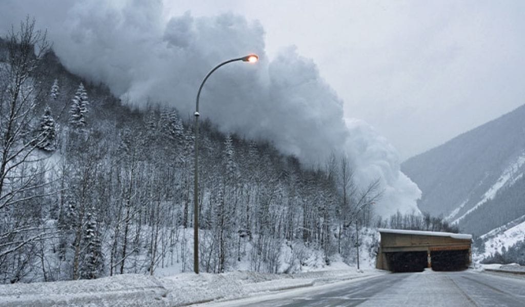
Avalanche Activity Already Spiking. On Tuesday, ski patrol teams were busy across the region. Lake Louise set off 28 controlled avalanches using explosives as part of routine safety work, including a few that were roughly 70 metres wide. Sunshine Village also carried out its own control work, setting off small slides.
Parks Canada triggered a much larger slide on Mount Bosworth near Kicking Horse Pass while doing highway safety work. That avalanche broke about a metre deep and sent snow toward the road, a sign that the snowpack is very reactive at the moment.
More Weather on the Way. Forecast models show another 20 to 40 cm of snow arriving Wednesday into Thursday, along with strong west and southwest winds. Valley temperatures will hover around zero. All of this will push the avalanche hazard up quickly.
Before heading out, check the weather and keep an eye on the Avalanche Canada website.
Reply